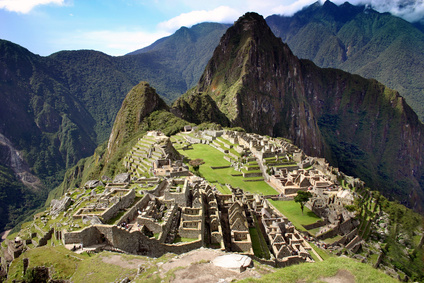
The architecture of Machu Picchu: ruins and sections of the city
 The Inca Empire was able to perform the most extraordinary architecture works that still can be appreciated from the large number of ruins left, all over the mountain system that surrounds the Citadel of Machu Picchu. Indescribable designs and great architectural organization were the main facts to make possible such an incredible city that was dividedin a number of sections. Each one of these areas was, at the same time, symbolizing and standing for the various neighborhoods; therefore, the different social classes that ranked the Inca citizens by granting them with a social status, was not only visible on the classification of the society but also on the city itself, its organization on its different neighborhoods that would prevent the access to the lower social classes.
Due to the rapid population growth that the Inca Empire was experiencing all over its territories, the Citadel was in need of a number of infrastructures and networks to expand its limits and be capable of hold such a large population. As a consequence, the city started developing a large number of farms and all kinds of structures all of them designed exclusively for the city itself to be able to supply such a vast population. This agricultural section of Machu Picchu at the South side of the city was an extension of the main farming area in the inner citybut, still, this was not an area large enough to supply an entire civilization that was facing overpopulation.
This agricultural project has been one of the most extraordinary architecture works because it was created to hold a large number of crop fields, well organized in farming terraces, all over the entire length of the slopes of the Valley. However, the challenging location was not a problem at all for the Inca civilization because they were very competent, so talented that they were able to create an amazing transportation network with more than eight different paths or roads that allowed the city to keep communications with the other regions of the Machu Picchu Mountains.
The agricultural section was separated apart from the main urban sectors within the city. The construction of a wall as a protective measure was in between both sections; the wall was about 400 meters long and had a fosse all along the wall. Although the fosse was originally designed to be the main drain system of the city, there were too many protective elements like the wall, the moat and a main gate fortified, elements that are obviously designed to provide the city with defensive measures. At the same time, the fosse is also part of the geologic fault which separates both sectors, something that the architects took advantage of for the city's design.
The inner city was split up into two main sections or districts. The one known as Hanan was the upper district for the nobility while the lower social class was confined in the area known as Hurin. Both metropolitan areas were separated from each other through two dividing lines like axis. The first of them was designed in several levels to adjust it to the mountainous slope, while the other dividing line that runs the complex horizontally from East to West was designed to become the main avenue that was decorated with a number of fountains that supplied water to the complex.The northern area had a high spiritual meaning and contains the sacred buildings where the civilization practiced a set of sacred rituals based on their astrological doctrines.